This Wednesday it will be hotter in Burlington, Vt., than in Miami—by a whopping 10 degrees Fahrenheit (5.5 degrees Celsius).
This topsy-turvy weather comes courtesy of a heat dome, a particularly intense and persistent area of high atmospheric pressure that creates heat waves. This week’s heat dome is expected to cause record-breaking temperatures in some places, particularly in northern New England, where certain areas could see the warmest temperatures in 30 years.
Such intense heat waves are happening more often, lasting longer and becoming ever hotter because of climate change. Similar events around the world last year helped make last summer the hottest in 2,000 years. But what is record-breaking heat now will become a normal summer in a few decades.
On supporting science journalism
If you're enjoying this article, consider supporting our award-winning journalism by subscribing. By purchasing a subscription you are helping to ensure the future of impactful stories about the discoveries and ideas shaping our world today.
The current heat dome is taking shape in part because of the jet stream. This fast-moving river of air high in the atmosphere helps guide weather systems across the U.S. as it undulates to the north and south. When it makes a particularly large jog northward, the air piles up and sinks, heating up as it does. The sinking air also suppresses cloud formation, allowing the sun to beat down on the ground—which, in turn, gets hotter itself and heats the air above it up even further. “Generally, the stronger the high pressure, the hotter the high temperatures can be,” says Bob Oravec, lead forecaster at the National Weather Service’s (NWS’s) office in College Park, Md.
The jet stream can get stuck in this configuration, causing a heat wave to continue to build and sometimes break records. That is likely to happen in some spots during this week’s heat dome event, particularly because these domes are more common in the U.S. west than in the East. “I don’t recall the last time we had one centered across the eastern U.S.,” Oravec says.
Extremely stubborn heat domes brought brutally scorching weather to Texas and the Southwest last summer, breaking records day after day for weeks. Another heat dome in 2021 obliterated records in the Pacific Northwest, with Portland, Ore., hitting 116 degrees F (47 degrees C).
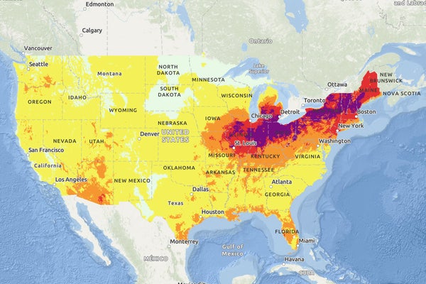
This week’s heat dome is centered over the Midwest, with the worst of the heat first hovering around the Great Lakes, then moving slowly eastward. The heat will peak in northern New England around Wednesday and Thursday. Temperatures are set to reach 97 degrees F (36 degrees C) in Burlington and in Bangor, Me., on Wednesday. The heat will crest in the New York City area around Thursday and Friday, with temperatures likely reaching 97 degrees F on Friday. Washington, D.C., and its surroundings can expect the worst conditions into the weekend, with a high around 100 degrees F (38 degrees C) on Saturday.
The heat wave poses a major public health risk: heat is the deadliest extreme weather event in the U.S. And the risk is compounded when temperatures soar early in the summer, before people have a chance to acclimate and may not be as prepared. Temperatures in northern New England this week will likely reach highs rarely even seen later in summer, when heat tends to be at its worst.
Humidity will also be a factor, making the air feel like more than 100 degrees F in many places. The NWS’s new HeatRisk mapping tool, which uses color coding to denote risk levels, has placed much of the affected area in the “major” and “extreme” categories. “This is a high-impact event, and people need to take the usual precautions,” Oravec says.
The risks are particularly acute for certain groups, including older people, very young children and people with certain health conditions. It can also especially endanger those who take medications that hamper their ability to sweat, those who work outside and those without housing. Such groups are advised to take precautions even if they’re in one of the NWS’s “minor” risk areas.
Experts caution that people should make sure they stay hydrated by drinking water even before they feel thirsty. Time outdoors should be limited with plenty of rest breaks, ideally in a place with air-conditioning. People are also urged to check on family members, friends and neighbors who might be in the highest-risk groups, particularly if they don’t have air-conditioning. That issue is of particular concern in the Northeast, where many people lack AC because it historically hasn’t been needed. Some places, such as New York City, make cooling centers available to residents to use during the day. People should also pay attention to their pets and make sure these animals have plenty of access to shade, water and air-conditioning.
“To combat heat’s effects on your body, it’s a good idea to combine multiple actions,” said Ashley Ward, who directs the Heat Policy Innovation Hub at Duke University, in a notice issued by the hub. “In addition to staying hydrated and using air conditioning or fans, you can take cool showers and immerse your arms over your elbows or your feet over your ankles in cool water.”
It is also important to note more than just the daytime highs. Temperatures in the affected areas are expected to stay unusually warm into the evening, making it harder to get a respite from the heat—especially for those without air-conditioning. “If you must ration cooling in your home,” Ward says, “consider prioritizing the bedroom so your body can recover from daytime exposures.”
